Sunday, July 1, 2012

Acadia's Classic Hike

The North Ridge Trail provides a great view of Frenchman Bay and Bar Harbor.
View of Cadillac Mountain from the Pemetic Mountain Trail.
Probably the most popular of the summit hikes in Acadia National Park is the trek up Cadillac Mountain. Cadillac is the highest mountain in the park (1,350 feet) but is probably better known as the first place the sun touches the US mainland every morning. While not a big mountain when compared to the massive peaks out west, it is a challenging walk along exposed granite ridges and culminates at a summit which offers a 360-degree view of Acadia, Bar Harbor, and the surrounding area. There are several paths up the mountain and we chose to ascend via the popular North Ridge Trail and return via the South Ridge Trail. Made for a challenging all-day hike but one well worth the effort.


Wednesday, June 27, 2012

Acadia's Carriage Roads

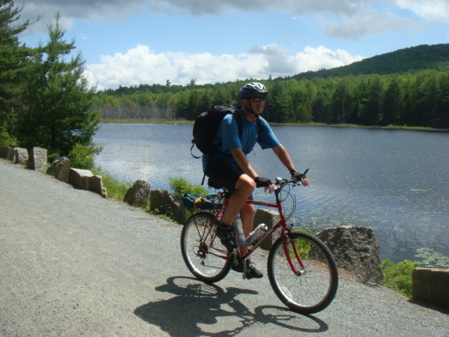
Great biking on Acadia National Park's carriage roads.
One of the really great features of Acadia National Park is the network of carriage roads that meander through the park. Built in the 1920s and 1930s by John D. Rockefeller, Jr., the roads are constructed of crushed rock and are open to horse-drawn carriages, hikers, and bicycles. An added feature are the more than 30 stone bridges Rockefeller had constructed, each with a unique design and perfectly blended into its surrounding setting. Since we are avid bicyclists, the carriage roads offer great views, challenging terrain, and a wonderful way to explore the park. More than 45 miles of carriage trails are open to bicycles and are well marked with signposts at key intersections.

Sunday, June 24, 2012

FDR's Summer Getaway

The Roosevelt's summer home on Campobello Island.
During our visit to Franklin Roosevelt's home in Hyde Park, NY, we noticed many photos of the young Roosevelt at his family's summer home on Campobello Island, New Brunswick, just across the Canadian border from Lubec, Maine. The home and surrounding gardens are now part of Roosevelt Campobello International Park, the only national park in the world administered by two countries. Franklin Roosevelt spent most summers here while he was young and it was here in 1920 that his polio symptoms first appeared, although he apparently contracted the disease at a Boy Scout camp in New York. Amazingly enough, he only visited the estate three more times after 1920, most likely due to his blossoming political career. Eleanor Roosevelt and Franklin's mother, Sara, continued to use the house for many years however. The park offers house tours, walking trails, and amazing views of the Bay of Fundy and its spectacular coast.

Saturday, June 23, 2012

A Light at Land's End

The West Quoddy Light is perched at the eastern-most point of the US.
About 100 miles up the coast from where we are in Acadia National Park is the town of Lubec, Maine. Lubec is a fishing community of about 1,500 located on the border with Canada and is the main access point for Campobello Island from the US. Campobello is home to Roosevelt Campobello International Park. We spent a night in Lubec as part of our visit to Campobello and discovered the West Quoddy Lighthouse has a wonderful museum that tells the history of this corner of the country. A stone behind the lighthouse marks this as the eastern-most point in the continental US. Perched on a rocky coastline with treacherous underwater rocks lurking just off shore, the West Quoddy light and many others along the southern coast of Main continue to provide much-needed guidance to mariners as they have since this area was settled.

Pots of Pink Gold

Most lobster pounds in Maine cook their lobsters in sea water over a wood fire.
I'm not sure how much revenue the lobstering business brings into the state of Maine, but it plays a major part in the economy here. Hard to believe that lobsters were once considered a trash food. They were so abundant that farmers used them as fertilizers and there is a popular story about a prisoner revolt initiated because the inmates were served lobster every night. Times have surely changed the standing of this pink crustacean in our culinary pecking order. Maine lobster fishermen can harvest any lobster between 3.5 and 5 inches long (measured along the carapace) but must throw back egg-bearing females. Lobstermen can have as many as 800 traps in the water at a given time, meaning they are constantly checking and re-baiting traps throughout the peak summer lobster season. Needless to say, lobsters are on virtually every menu here and keep a lot of folks employed in the region.

Thursday, June 14, 2012

A Whale of an Afternoon

Humpback whale feeding on krill and small fish.
This graphic shows how large these whales are.
One of the biggest reasons people visit Cape Cod is the opportunity to view whales relatively close to shore. We thought our chance was gone after a spell of rainy, windy weather that forced the whale watching fleets to remain in the Provincetown harbor. But, on our final day on the Cape, we caught a break and took a 3 hour whale watch trip out to Stellwagon Bank, a shallow spot in the ocean off the tip of Cape Cod and one of the most accessible places to view migrating humpback whales. Humpbacks are large (40 to 50 feet long and 80,000 pounds) baleen whales that spend the winter months in the Carribbean and the summer feeding months in the waters of the cold North Atlantic. They eat krill and small fish, mostly by blowing rings of bubbles below the surface which "herds" the fish in a big circle, allowing the whale to fill its massive lower jaw with thousands of fish as it slowly rises to the surface. A trip on a commercial whale watching vessel is a great way to observe these amazing creatures up close.

Friday, June 8, 2012

The Cape's Most Popular Tourist Attraction

Okay, I know it's a truck but they didn't allow photos on the tour.
Yeah, I don't know how they figure out what makes something the most popular, but on a rainy Cape Cod day, we made the drive to Hyannis for a tour of the Cape Cod potato chip facility. We have made a tradition of taking at least one industrial tour during our summer journeys, so we can check that off our list for this year. And, apparently, we are not that unusual -- more than 250,000 people take the tour each year. Cape Cod Potato Chips began as the dream of two small business owners who set up shop in a small store front in Hyannis in 1980. The big crunch of the kettle cooked chips soon became a local favorite. News of the chips quickly spread as tourist sampled the chips and took bags home to share. The business soon grew out of the store-front and the rest is history. The self-guiding tour takes about 10 minutes and lets you view the various processes that go into making the chips. Best part is the finale when the tour ends up in the gift shop and free sample bags of chips!

Cape Pedaling

Easy, scenic riding on the Cape Cod Rail Trail.
Great view of the Atlantic Ocean at trail's end.
We were fortunate to get a break in the rainy weather long enough to ride the magnificent Cape Cod Rail Trail. The trail is fully paved and runs for 22-miles from Dennis to Wellfleet. If you curl your left arm  like you are making a muscle, your arm would be in approximately the same shape as the Cape. Dennis would be about where you bicep is and Wellfleet would be halfway up your forearm. Like most rail trails, the Cape Cod Rail Trail has a fairly level grade, making for an easy ride. And, it passes through several historic towns and along picturesque ponds, cranberry bogs, and marshes. Highly recommend if you are on the Cape and have access to a bike.

Monday, June 4, 2012

I Landed in Provincetown and All I Got Was This Lousy T-shirt

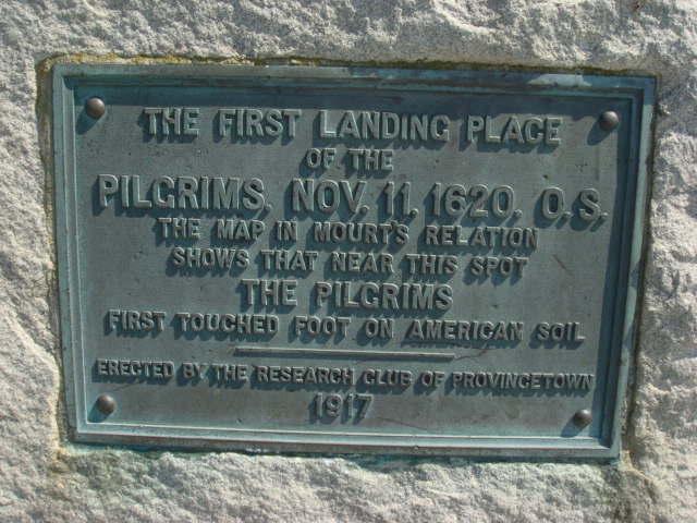
This plaque commemorates the spot where the Pilgrims landed near Provincetown.
This shop might have been where the Pilgrims purchased their souvenirs.
If the Pilgrims had sailed into Provincetown in 2012 instead of 1620, that might be have been a popular seller among the crowd on the Mayflower looking for a place to practice religious freedom. They spent a short time in P-town before moving on to Plymouth. Now, we were very impressed with the number of high-quality artist studios and interesting restaurants located in the main tourist areas near the waterfront, but, like most similar seaside destinations, P-town has its share of tacky t-shirt and fudge shops. We rode our bikes from the Cape Cod National Seashore visitor center into town to avoid having to navigate around the narrow streets in my dually. That was a tip suggested by a ranger at the park and it was a great recommendation. The 5-mile paved bike trail traverses the dune landscape of the park and ends just a short ride from downtown P-town. It's a great place to stroll on a sunny afternoon. We also were fortunate to see a pod of humpback whales splashing just off the coast from the park visitor center observation deck.

JFK's Summer White House

The JFK Museum in downtown Hyannis, MA.
The museum features many items from the 1960 Presidential campaign.
Keeping with our visits to historic sites related to US Presidents, we drove over to Hyannis to the JFK Museum, which commemorates John F. Kennedy's ties to the area and the role the Kennedy compound played during his 1960 campaign and through his presidency. The museum houses more than 80 photos, mostly candid shots of JFK with family and friends, spanning his years there between 1934 and 1963. A video, narrated by Walter Cronkite, includes some rare footage of JFK during the time the Hyannis property served as his campaign headquarters and, after his election, as a popular setting for hosting visiting foreign dignitaries or for getting away from the pressures of the office. Since the Kennedy compound is not open to the public, this is a good way to learn about the ties the 35th President has to Cape Cod.

Wednesday, May 30, 2012

My Visit to Big Pink

Big Pink, a rock-n-roll landmark.
Hidden down a one-lane dirt road in West Saugerties, NY, is a split-level, pink-shingled house that has the most famous basement in Rock-n-Roll. This is the house where Bob Dylan lived in 1967,with members of The Band. Dylan and The Band recorded The Basement Tapes in the basement on a 2-track recorder back in 1967 but the album wasn't released until 1975 as a double album. The Band, (Robbie Robertson, Rick Danko, Richard Manuel, Garth Hudson, and Levon Helm) would eventually live there and rent out the house.The Band recorded the legendary Music From Big Pink album, one of my all-time favorite albums, there in 1968, along with the follow-up The Band (the "brown" album) in1969. Bob Dylan also recorded his John Wesley Harding album there. Also other well established artists such as Eric Clapton and George Harrison would frequent Big Pink around this time, and even write and rehearse songs there. The house looks much the same as it did on the back of the Music From Big Pink album cover more than 40 years ago. As I stood there alone in the quiet of a late afternoon, I could swear I heard Dylan and the boys down there in the basement.

Olana

Olana, the Persian/Moorish-inspired home of Frederic Edwin Church.
Standing on a hill with wide views of the Hudson River and the Catskill Mountains is Olana State Historic Site in Hudson, NY. Olana was the home, studio, and estate of Frederic Edwin Church, one of the major figures in the Hudson River School of landscape painters in the 19th Century. Church first sketched on what was then a working farm in 1845 and purchased the property in 1860. Over the next 30 years, he continuously improved the 250-acre property, adding scenic carriage roads, gardens, orchards, a man-made lake, and more than 30,000 trees. The mansion itself is done in a Persian and Moorish style which Church designed based on his travels to the Middle East. Most of the furnishings are original and were collected by Church from his travels.

Tuesday, May 29, 2012

Cruising the Walkill Valley

Riding through the apple orchards along the Walkill Valley Rail Trail.
The restored railroad bridge over the Walkill River.

If you followed this blog last year, you know that we like to discover rail trails in the vicinity of the campgrounds where we stay. There are several options in the Hudson Valley, one of which is the Walkill Valley Rail Trail, which runs for about 16 miles from Rosendale, through New Paltz, and south past Gardiner. This is a relatively new trail that is still being developed, and takes riders past apple orchards, over a restored bridge spanning the Walkill River, and through miles of dense forest. One of the benefits of traveling in the spring is seeing all the wildflowers blooming this time of year and the Walkill rail trail did not disappoint.

The Gigantic Kaleiedoscope

The World's Largest Kaleidoscope is located in an old grain silo.
Like, far out, man.
Since we were just down the road from Woodstock, NY, we just couldn't pass up the chance to visit a psychedelic roadside attraction. Billed as the World's Largest Kaleidoscope (and recognized by The Guinness Book of World Records), the Kaatskill Kaleidoscope in Mt. Tremper is housed in a 60-foot tall former grain silo. The $250,000 kaleidoscope was designed in the 1960s  by artist Isaac Abrams and his son Raphael and was completed in 1996. About 20 people can fit into the silo at a time. Visitors must lean back against sloping padded boards with sliding neck supports, allowing an easy view up through the kaleidoscope in the silo. The day we visited, Paula and I were the only ones there, so the attendant let us lay on the floor. There are three different shows, all accompanied by music written by a local composer, that last about 10 minutes. I must say, laying on the floor listening to psychedelic music and looking up at the show in the kaleidoscope really was a groovy way to spend an afternoon. Peace.

A Visit to Springwood

The birthplace and home of Franklin Roosevelt
Franklin and Eleanor Roosevelt are buried on the property.
After arriving in the Hudson Valley, we set out to visit one of the most famous residences of an American President. Springwood was the birthplace and long-time home of Franklin D. Roosevelt, our 32nd President, and is located high on a bluff in Hyde Park, NY, with stunning views of the Hudson River below. The 300-acre site is run by  the National Park Service and includes the FDR Presidential Library, which FDR established as the first of its kind in 1943. FDR's father purchased the land in 1866 and built the original house shortly after. In 1915, FDR and his mother, Sara, undertook a large-scale enlargement and remodeling that brought the house to its current state. One of the most interesting features of the house is the manually operated elevator that FDR used to move between the first and second floors. After he was paralyzed by polio in 1921, he was unable to walk, but retained full use of his upper body. A pulley system in the elevator allowed him to wheel his chair into the elevator and raise or lower himself between floors using his arms. FDR and his wife, Eleanor, were also dog lovers -- their two favorites are buried next to them on the grounds.
Beloved dogs Chief and Fala are buried next to the Roosevelts

Tuesday, May 22, 2012

A Two-State Lunch Break

Straddling the PA-MD border.
While we were camped at Rocky Gap State Park in the mountains of western Maryland, we decided to hike the Evitt's Mountain Trail, the park's most challenging walk. The trail ascends about 1,200 feet in 4 miles and crests Evitt's mountain at the border between Maryland and Pennsylvania, better known as the Mason-Dixon Line. While most people know the line as the border between north and south during the Civil War, it originally was named for two surveyors (Mason and Dixon) who were hired to delineate the border of Pennsylvania and Maryland in the early 1700s. Today, there is a post marking the border. We had lunch straddling the border, Paula in the state where she was born, Maryland, and me in the one in which I was born, Pennsylvania.

Riding the GAP Bike Trail


The WMSR steam engine was built in 1916 and really makes the uphill climb to Frostburg a pleasure.


We discovered a great way to get a bike ride in and ride a historic railroad in the same day. The Western Maryland Scenic Railroad (WMSR) is a heritage railroad based in Cumberland, Maryland, and runs both steam- and diesel-powered trains from Cumberland to Frostburg, about 16 miles west. We opted for the steam-powered engine originating out of the former Western Maryland station in Cumberland, which also houses one of the six visitor centers of the Chesapeake and Ohio Canal National Historical Park. This station was built in 1913.The track, which for the most part follows a former Western Maryland Railway line, proceeds northwest from Cumberland through "the Narrows", a deep water gap, proceeds up the Allegheny Front , and terminates at the former Cumberland and Pennsylvania Railroad depot in Frostburg. The train lays over there for about 90 minutes to allow passengers to visit the town, and the locomotive is turned back there on a turntable before it returns to Cumberland by the same route. They let you bring your bike along and instead of making the trip back to Cumberland on the train, you can ride back on the Great Allegany Passage (GAP) Trail. It's a bike-only trail that is a gradual downhill coast all the way back to Cumberland. Highly recommend the trip for anyone interested in trains and looking for a way to get in some exercise. 

Thursday, May 17, 2012

How to Beat the Cades Cove Traffic Jam

The spring wildflowers are in bloom in Cades Cove.
Cades Cove is one of the most popular destinations in Great Smoky Mountains National Park, and its 11-mile loop road is notorious for traffic jams of tourists inching along the one-lane road. I found a great way to beat the traffic -- ride a bike. For hundreds of years Cherokee Indians hunted in Cades Cove but archeologists have found no evidence of major settlements. The first Europeans settled in the cove sometime between 1818 and 1821. By 1830 the population of the area had already swelled to 271. Cades Cove offers the widest variety of historic buildings of any area in the national park. Scattered along the loop road are three churches, a working grist mill, barns, log houses, and many other faithfully restored eighteenth and nineteenth century structures. With sunny skies and perfect temperatures, I pedaled the loop road twice, moving as fast as the traffic, and getting a lot better gas mileage. For a flatlander like me, though, the hills proved to be quite challenge.

Tuesday, May 15, 2012

The Hike that Took 30 Years to Finish

It took 30 years to finish, but we conquered the Ramsay Cascades Trail.

The cascades were in full flow after all the rain in the park this week.
As mentioned in my previous post, the main reason we started our trip with a visit to Great Smoky Mountains National Park was to cross the Ramsay Cascades Trail off of our "to do" list of hikes. We aborted our first try in 1982 and never made it to the trail in 2000 because of a washed out bridge. Today, we were at the trailhead by 9:30 this morning and figured we had until 3:00 PM to finish before the predicted thunderstorms hit. The trail is a steady uphill climb (from 2,250 feet elevation to 4,400 feet) over 5 miles (10 miles round trip) and follows the middle prong of the Little Pigeon River. We reached the cascades in time for lunch with a few fellow hikers before heading back down the slippery trail. Just before reaching the truck, the skies opened up in true Smokies fashion and we were drenched for the second day in a row. But at least we made it to the cascades and we consider our trip to the Smokies a rousing success.

Monday, May 14, 2012

Once Again, Rain in the Smokies


The rain has been really good for the mountain laurel.
Morning mist on the trail to Sutton Ridge, Great Smoky Mtns. Natl. Park, TN
Every time we visit the Smoky Mountains, it seems we bring torrential rains with us. Our main reason for stopping here on our way north is to finally complete the Ramsay Cascades trail. We first attempted the trail in 1982, but were forced to turn back near the top due to heavy fog, rain, and an insufficient supply of water -- really embarrassing for us as hikers. We returned in 2000 to conquer Ramsay, but two days of heavy rain washed out the bridge leading to the trailhead. So, we have returned in 2012 to get this trail off of our list of "must do's" before we die. After 2 days of steady rain, it looks like we'll make our third attempt at the trail tomorrow. We'll let you know how it turns out. In the meantime, we did a short hike to Sutton Ridge today, in the rain, of course. At least the mountain laurel is in full bloom.

The Town Sherman Refused to Burn

The courthouse in downtown Madison, GA.
First night we camped just outside Madison, GA, which is about 50 miles southeast of Atlanta. When Paula asked the friendly campground manager what Madison was known for, his reply was that Madison was the only town between Atlanta and Savannah that Sherman didn't burn. The reason -- Sherman's girlfriend lived in Madison. Nice bit of Civil War trivia. Unfortunately, it isn't true. According to the Georgia Encyclopedia, Sherman was south of the area when one of his regiments passed through Madison. Sherman was good friends with Joshua Hill, a former US Senator who lived in Madison, and he reportedly sent word to his troops not to burn Madison out of respect for that friendship. Whatever the real story, downtown Madison today is well-preserved, charming southern town.

On the Road Again!

Hard to believe it's been 10 months since we finished last summer's trip out west. But, here we are again, heading out to explore all the great places our wonderful country has to offer. Our primary goal on our first day was to get further than the 14 miles north of Gainesville we did last year when we had our trailer tire blow out. I am happy to report, we made it all the way to Madison, GA without an incident. Good to get the first day behind us. We are both a bit disorganized but I'm sure after a few days, we'll know where everything is. Hope you'll follow us as we roll down the road.